
Monday night, the DC area will be affected by a major snowstorm resulting from the explosive combination of two piece of energy in the jet stream. Expect widespread delays and cancellations Tuesday as well as possible power outages.
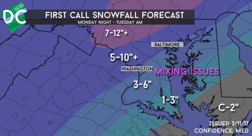
Timing: Starts 7-9 PM Monday, lasts until 7-9 AM Tuesday. Light snow many continue throughout the day Tuesday. Heaviest snow is 11 PM-4 AM
Amounts: 1-3″ on the western shore, 3-6″ southeast of I-95 and in the city, 5-10″ northwest of I-95, and 7-12″ in northern and northeastern Maryland
Temperatures: 34-36 at onset falling to 30-33. Surface temperatures will determine the location of the rain/snow line.
Winds: 10-20 mph gusting to 30 mph. There may be some blowing snow but blizzard conditions are not expected.
Impacts: Roads will quickly become snow covered and hazardous shortly after dark Monday. Widespread delays and closure Tuesday and possibly into Wednesday and Thursday in hard-hit areas. We expect almost all area schools to close Tuesday. Heavy wet snow piling up on tree branches will lead to power outages.
Boom scenario: If the coastal storm deepens more rapidly and throws more precipitation back, amounts could be much higher, possibly up to 12-18″ or even higher throughout the area. This would also keep temperatures down and decrease mixing.
Bust scenario: If the storm develops more slowly, heavy precipitation will not break out and snow will have trouble accumulating. Another threat is that the storm may amp up too much and draw warm air into the system, turning the snow to sleet or freezing rain. In one of these scenarios, DC would pick up just a few sloppy inches with the northwest suburbs still getting a respectable 3-6″/4-8″ snow.
Preparation: It hasn’t snowed in a meaningful way here since the blizzard last year, so make sure you are ready for what could be a serious storm. Beyond the usual travel impacts, this storm also poses the threat for power outages: considering the very cold air coming after, this could become dangerous. Make sure you are prepared in the event that you lose power.